Laminated atmospheres

classic Classic list List threaded Threaded
1 message Options
Reply | Threaded
Open this post in threaded view
|

Laminated atmospheres

Nick Thompson
WordPress.com

Hi, everybody,


Tar Baby Alert! 


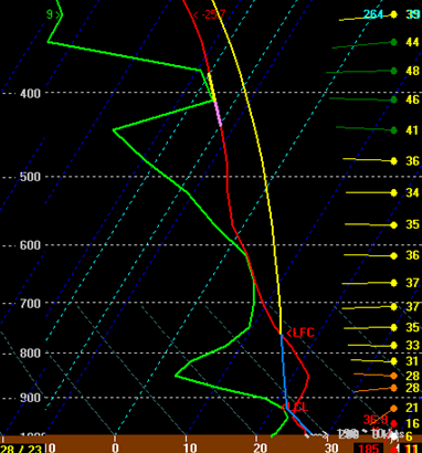
The blog entry at the very bottom of this message provides  wonderful example of an atmospheric cap, the phenomenon I have been trying to find somebody on this list to join me in thinking about. .   Just below is a skew-T diagram for Hartford for the time when a severe outbreak that the blog’s author predicted did NOT occur.  The author of the blog is saying that the diagram illustrates a” strong cap”, and that the strong cap prevented any strong thunderstorms, hail, derecho, or tornadoes from forming.


This skew-T shows the pressure (horizontal dotted lines) against temperature (faint dotted green lines “skewed” to the right). For orientation, 500 mb is about 18k feet, where approximately half the atmosphere is below.   The  bright wiggly lines tell us something about the conditions through which the balloon passed on its way up through the atmosphere.  The temperature is the mostly red line and the dewpoint is the green line.  If a sounding followed one of these green lines all the way up, it would not change temperature at all.  It would of course get relatively warmer which is shown by the fact that it would cross the dry adiabats, the fainter lines skewed to the left.  Air that FOLLOWS a dry adiabat is maintaining its expected temperature as the pressure falls around it.  The OTHER line, the one that is blue at the bottom and yellow at the top is what the temperature sounding WOULD have looked like if the atmosphere through which the balloon traveled were uniform in temperature (but not necessarily in moisture) .   The diagram shows that this atmosphere is divided into three layers.  The lowest level, the “boundary level”, the “cap”, and finally the region of instability.  So a comparison of that path with the other two tells us how the atmosphere deviates from its expected values.  Note that the temperature falls as expected for the first it, then becomes relatively WARMER (and dryer) for a while, and then relatively cooler (and moister) for a while.  The bottom bit is the boundary layer (where the atmosphere is constantly mixed by friction with the earth), the warm bit is the cap, and the cool bit is the region of instability  


What fascinates me is why these layers maintain their positions, given their relative densities.  A couple of people have told me that I should EXPECT them to do so, unless some mechanical force causes one to intrude upon the other.  That is where the matter stands at the moment.  I  would LOVE for others to join me in trying to understand this phenomenon  I am reduced to floating slivers of frozen beet juice gently floated on top of glasses of water that have been allowed to stand for a day. 


I won’t hold my breath.  I realized that most of you do not have the luxury of being both retired and on vacation.   And cooped up in a mosquito infested bog. 


Nick


From: Way Too Much Weather [mailto:[hidden email]]
Sent: Saturday, July 28, 2012 10:57 PM
To: [hidden email]
Subject: [New post] Thursday’s Bust – What Went Wrong?


New post on Way Too Much Weather


Thursday’s Bust – What Went Wrong?

by ryanhanrahan

All the ingredients seemed to be lining up for a significant severe weather event, particularly in western Connecticut and adjacent parts of New York. What did we see? Sporadic damage reports and a dying squall line that moved out of the Poconos.

There was certainly a  lot of potential on Thursday. Models had been showing moderate amounts of instability and very strong shear. Forecast and observed hodographs indicated the potential for tornadoes in any discrete cells that developed or along squall lines.

18z NAM 6 hour HVN 0-3km hodograph forecast

While deep layer (and low level) shear was sufficient for supercells a strong cap near 850mb prevented convection from developing ahead of the main line. Here's a 23z RAP sounding (initialization) for HVN and you can see right off the bat the problem.

Yikes!!! That's a lot of CIN. The LFC is nearly 775mb with a large negative area on that sounding. While the squall line looked exceptionally impressive over Pennsylvania it began to fizzle as it worked east. The large amount of convective inhibition became problematic as the squall line's cold pool was unable to force surface based parcels to the LFC.

Our models had shown that the CIN present during the day would weaken but apparently that was not the case. While low level moistening helped eliminate some of the negative area it was not enough. The cap was also quite low. Typically we see caps around 700 mb... not 850mb! The exceptional warm 850mb temperatures (over +22c) effectively served to cap convection.

With a convective temperature of 95F we just weren't going to get rid of that CIN. The warm layer at 850mb (NAM did do well with this) was just too much. With stronger surface heating and more low level moistening things may have been different.

The storms were most certainly a bust. The Storm Prediction Center issued the first ever (that I can remember) day 2 moderate risk for Connecticut. The probabilities for severe wind and significant severe were some of the highest you'll ever see in Connecticut.  In fact while the event was ongoing the SPC sent out a discussion saying they contemplated an upgrade to "high risk" which would have been the first time since May 31, 1998 parts of the state have been in a high risk! As the squall line was leaving the Poconos the SPC expected the storm to strengthen and called it a derecho.

In the end a lack of synoptic forecasting (500mb heights were neutral from 18z-00z) and strong CIN thanks to a stout low level cap did our severe chances in. Given the potential it was important to mention the possibilities. Severe weather is a challenge to forecast - certainly much more challenging than a winter snowstorm!

Comment

   See all comments


Unsubscribe or change your email settings at Manage Subscriptions.

Trouble clicking? Copy and paste this URL into your browser:
http://ryanhanrahan.wordpress.com/2012/07/28/thursdays-bust-what-went-wrong/


============================================================
FRIAM Applied Complexity Group listserv
Meets Fridays 9a-11:30 at cafe at St. John's College
lectures, archives, unsubscribe, maps at http://www.friam.org